
High and Low Pressure: the big picture
Learning Objectives
Understand why air rises at the equator.
Understand why the air at the Tropic of Cancer is dry.
OK. Let’s draw the first line on the earth (0 degrees latitude). This is our equator. And then we draw two lines, on both sides of the equator. They are the Tropic of Cancer (23.5 degrees north of the equator) and the Tropic of Capricorn (23.5 degrees south of the equator). The line near the North Pole is the Arctic Circle (66.5 degrees N), and the line near the South Pole is the Antarctic circle (66.5 degrees S).
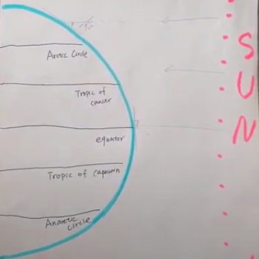
Here is our Sun. The pencil represents the sunlight. And what we can see is that at the equator, the sunlight is direct to the equator. It’s 90 degrees. But when we get to the Arctic Circle, the angle is going to be smaller. This means that most of the energy and the heat from the sun will be at the equator.
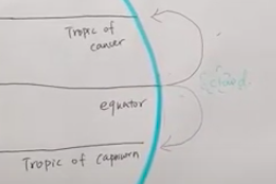
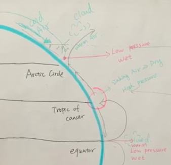
Because it’s really warm and hot at the equator, the air will be rising. And as the air rises, the air gets cold, and the water vapor condenses. So the clouds will be formed here, above the equator. This will be low pressure because this is rising air. And it will be wet, because the water vapor condenses here.
At the Tropic of Cancer, the air separates in 2 directions. One is bent toward the equator, and the other will go up to the Arctic Circle. When it reaches the Arctic Circle, it meets cold air from the North Pole — we call this a polar front. Because it is cold air, the warm air from the equator is forced to rise. And here the water vapor condenses, so the clouds form.
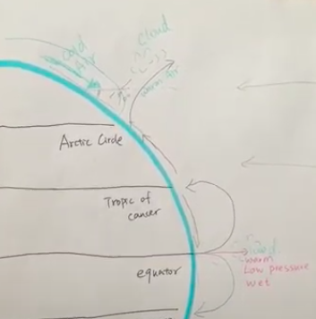
As I introduced before, the rising air will always cause low pressure. And also because clouds form here, the water vapor condenses, so here it will be really wet.
The last part will be the Tropic of Cancer, as shown on our graph. We find here is the sinking air. The warm air from the equator will sink here. So here will represent high pressure, and here will be most of the deserts on the earth. So here it will be really dry.
This is the whole North hemisphere of our earth. And on the South hemisphere, all the things are the same process. The sinking air will be really dry because most of the water vapor will be trapped in the atmosphere. And then when they reach the Antarctic Circle they also meet cold air from the South Pole, so the warm air is forced to rise. As it rises, it will be really wet and it will form the clouds and the low pressure. The whole process is all similar.
What we always need to remember is that sinking air always leads to high pressure and the place where air sinks is always dry. But for rising air, this will be another story, because rising air always represents low pressure and it will always be really wet. This cycle is called a Hadley Cell.
