
Types of Clouds
Learning Objectives
Know the altitudes associated with low, mid-level, and high clouds.
Be able to describe one type of each cloud and tell what weather it predicts.
Today we will be learning about different types of clouds. We will cover altitudes associated with low, middle, and high level clouds as well as an example of each type of cloud and the weather it predicts.
To start off, all clouds contain some similarities, they are all made up of water droplets or ice crystals that float in the sky. However, the different appearance of these clouds help us predict changes in the weather.
High-Level Clouds
First, we have high level clouds. These clouds float in the sky at a level around 16,500-45,000 feet. That’s way up where airplanes fly and taller than all the mountains in North America! There are three types of high level clouds: Cirrus, Cirrostratus, and Cirrocumulus. We will go over Cirrus clouds in more detail.
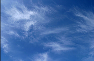
Cirrus Cloud
Cirrus clouds like the one pictured above (Figure 1) are light, feathery clouds that comprise mainly ice crystals. Cirrus clouds form when wind currents spread the ice crystals around into strands. Cirrus clouds indicate that a change in the weather is on its way. When you see these clouds in the sky, expect warmer or cooler weather to be coming!
Mid-Level Clouds
Next we will cover mid-level clouds. These clouds float in the sky at a height of 6,500-23,000 feet, this is way up in the sky just below where airplanes fly. There are three types of mid-level clouds: Altocumulus, Altostratus, and Nimbostratus. We will cover Altocumulus clouds in more detail.
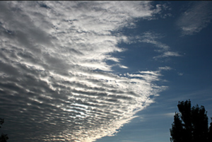
Altocumulus Clouds
Altocumulus clouds like the one above (Figure 2) have patchy white and gray layers. They seem to be made up of rows and are very fluffy in appearance. These clouds don’t produce rain very often and therefore predict fair weather.
Low-Level Clouds
We also have low-level clouds which float at a height of less than 6,500 feet. These clouds consist of cumulus, stratus and cumulonimbus.
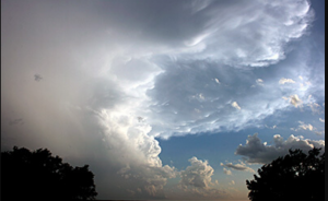
Cumulonimbus Clouds
Cumulonimbus clouds like the one above occur on very hot days when warm, wet air rises (Figure 3). They are huge and fluffy and from far away can look like mountains. These clouds predict rain, hail, and in some cases, tornadoes.
Special Clouds
Lastly, we have special types of clouds which don’t fit into the other categories. One example of a special cloud is a contrail cloud. (Pictured below).
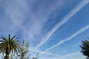
These clouds don’t form naturally! They are formed by high-flying jet airplanes. They are still clouds because they are made up of water droplets from the exhaust of jet engines. These clouds can provide info about the layers of moisture in the sky.
Here’s a link to a fun cloud matching game! https://scied.ucar.edu/clouds-memory-game
Water Droplets are water vapormolecules that have codensed to form liquid water.
