Reading a weather map
Learning Objectives
Know what a weather front is.
Know how weather fronts move in North America.
What is the weather front?
Weather front is a boundary separating two masses of air. There are four different fronts. They are cold front, warm front, stationary front, and occluded front.
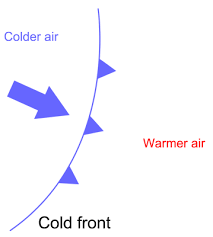
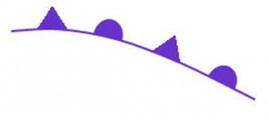
Cold front is when the mass of cold air moves to replace the mass of warm air which results in cold temperatures, torrential rains, and high wind speeds. This type of front is drawn in a solid blue line with blue triangle and can be seen moving typically from northwest to southeast.
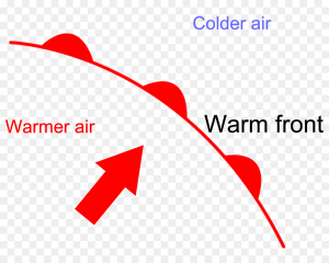
Warm front is when the mass of warm air moves to replace the mass of cold air which results in rainy to clear skies. This type of front is drawn in a solid red line with red semi circles and can be seen moving from southwest to northeast.
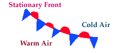
Stationary front is when both cold front and warm front meet which brings a long rainy period at just one spot. This type of front is drawn in both cold front and warm front symbol.
Occluded front is when cold front moves faster than warm fronts and sometimes cold front catches up to warm front. This type of front is drawn in both triangles and semicircles with purple color and it brings dry air.
On the weather map, there are also big blue letters H and big red letters L. Those two letters represent the high and low pressure areas. In a low elevation area, the pressure is high before there is more atmosphere pushing down. Up high in the mountain, there is barely any pressure which is the reason why you would need a gas mask to breathe when you’re at a high elevation area.
Atmospheric pressure can also rise when the area is hit by warm air. So areas with the big letters L are surrounded by a warm front as the area brings warm temperature. It goes the opposite when the area is cold. The atmospheric pressure is high at cold areas as the gas molecule slows down when there isn’t enough energy to move the particle around. Those areas would be surrounded by cold fronts.